


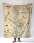

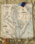


Chesapeake Bay Antique Map Blanket
This Civil War era Chesapeake Bay Map Blanket features a restored 19th-century nautical chart of one of America’s most historically significant waterways. Once a vital corridor for naval operations, shipbuilding, and coastal trade during the Civil War, the Chesapeake Bay is captured here in beautiful archival detail. Soft, durable, and designed to be both functional and meaningful, this blanket ships next business day—perfect for gifting or everyday use.
Details & Features
-
Authentic Civil War era Chesapeake Bay map (19th-century chart)
-
Highlights historic ports, rivers, and coastal towns of Maryland & Virginia
-
Ultra-soft fleece with high-resolution archival printing
-
Generous throw size for couch, bed, or cabin
-
Designed and printed in the USA
-
Ships next business day from our Fall River studio
Perfect For
-
Civil War history enthusiasts
-
Chesapeake Bay sailors and boaters
-
Maryland & Virginia coastal homes
-
Museum-quality, place-based gifts


